South Dakota County Map
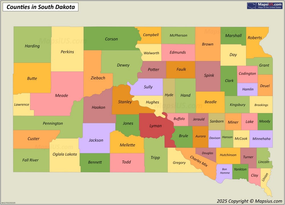
South Dakota consists of 66 counties, each of which functions as a local government unit.

About the map:
This South Dakota County Map shows the state border, county borders, and county names.
Attribution is required! You may download, print or use the above map for educational, personal and non-commercial purposes. You must place a hyperlink (to this page) with attribution next to the image you use.
Map of Counties and County Seats in South Dakota

About the map:
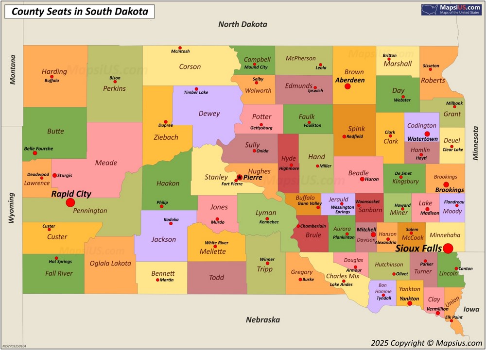
This Map of Counties and County Seats in South Dakota shows state borders, state names, state capital city, county borders, county names and county seats.
County seats are indicated by a red circle, the state capital city is indicated by a star in the red circle. The larger the city in terms of population, the larger the circle on the map and the larger the font of the city name.
Attribution is required! You may download, print or use the above map for educational, personal and non-commercial purposes. You must place a hyperlink (to this page) with attribution next to the image you use.
List of counties in South Dakota
South Dakota consists of 66 counties, each of which is an administrative region of the state. Meade County, the largest in area, covers approximately 3,471 square miles (8,990 km2). Minnehaha County, the most populous, is home to more than 208,000 people.
| County | County Seat | Area | Population (2024)[1] | FIPS Code |
|---|---|---|---|---|
| Aurora County | Plankinton | 708 sq mi (1,834 km2) | 2,752 | 003 |
| Beadle County | Huron | 1,259 sq mi (3,261 km2) | 19,459 | 005 |
| Bennett County | Martin | 1,185 sq mi (3,069 km2) | 3,289 | 007 |
| Bon Homme County | Tyndall | 563 sq mi (1,458 km2) | 7,071 | 009 |
| Brookings County | Brookings | 794 sq mi (2,056 km2) | 36,359 | 011 |
| Brown County | Aberdeen | 1,713 sq mi (4,437 km2) | 37,495 | 013 |
| Brule County | Chamberlain | 819 sq mi (2,121 km2) | 5,261 | 015 |
| Buffalo County | Gann Valley | 471 sq mi (1,220 km2) | 1,825 | 017 |
| Butte County | Belle Fourche | 2,249 sq mi (5,825 km2) | 10,891 | 019 |
| Campbell County | Mound City | 736 sq mi (1,906 km2) | 1,342 | 021 |
| Charles Mix County | Lake Andes | 1,098 sq mi (2,844 km2) | 9,343 | 023 |
| Clark County | Clark | 958 sq mi (2,481 km2) | 3,974 | 025 |
| Clay County | Vermillion | 412 sq mi (1,067 km2) | 15,245 | 027 |
| Codington County | Watertown | 688 sq mi (1,782 km2) | 29,278 | 029 |
| Corson County | McIntosh | 2,473 sq mi (6,405 km2) | 3,747 | 031 |
| Custer County | Custer | 1,558 sq mi (4,035 km2) | 9,330 | 033 |
| Davison County | Mitchell | 436 sq mi (1,129 km2) | 19,907 | 035 |
| Day County | Webster | 1,029 sq mi (2,665 km2) | 5,408 | 037 |
| Deuel County | Clear Lake | 624 sq mi (1,616 km2) | 4,335 | 039 |
| Dewey County | Timber Lake | 2,303 sq mi (5,965 km2) | 5,322 | 041 |
| Douglas County | Armour | 434 sq mi (1,124 km2) | 2,849 | 043 |
| Edmunds County | Ipswich | 1,146 sq mi (2,968 km2) | 4,027 | 045 |
| Fall River County | Hot Springs | 1,740 sq mi (4,507 km2) | 7,359 | 047 |
| Faulk County | Faulkton | 1,000 sq mi (2,590 km2) | 2,136 | 049 |
| Grant County | Milbank | 682 sq mi (1,766 km2) | 7,618 | 051 |
| Gregory County | Burke | 1,016 sq mi (2,631 km2) | 4,110 | 053 |
| Haakon County | Philip | 1,834 sq mi (4,750 km2) | 1,851 | 055 |
| Hamlin County | Hayti | 511 sq mi (1,323 km2) | 6,596 | 057 |
| Hand County | Miller | 1,437 sq mi (3,722 km2) | 3,097 | 059 |
| Hanson County | Alexandria | 435 sq mi (1,127 km2) | 3,477 | 061 |
| Harding County | Buffalo | 2,671 sq mi (6,918 km2) | 1,325 | 063 |
| Hughes County | Pierre | 741 sq mi (1,919 km2) | 17,526 | 065 |
| Hutchinson County | Olivet | 813 sq mi (2,106 km2) | 7,416 | 067 |
| Hyde County | Highmore | 861 sq mi (2,230 km2) | 1,215 | 069 |
| Jackson County | Kadoka | 1,869 sq mi (4,841 km2) | 2,737 | 071 |
| Jerauld County | Wessington Springs | 530 sq mi (1,373 km2) | 1,689 | 073 |
| Jones County | Murdo | 971 sq mi (2,515 km2) | 874 | 075 |
| Kingsbury County | De Smet | 838 sq mi (2,170 km2) | 5,261 | 077 |
| Lake County | Madison | 563 sq mi (1,458 km2) | 11,006 | 079 |
| Lawrence County | Deadwood | 800 sq mi (2,072 km2) | 28,809 | 081 |
| Lincoln County | Canton | 578 sq mi (1,497 km2) | 75,244 | 083 |
| Lyman County | Kennebec | 1,640 sq mi (4,248 km2) | 3,721 | 085 |
| Marshall County | Britton | 839 sq mi (2,173 km2) | 4,395 | 091 |
| McCook County | Salem | 575 sq mi (1,489 km2) | 5,771 | 087 |
| McPherson County | Leola | 1,137 sq mi (2,945 km2) | 2,307 | 089 |
| Meade County | Sturgis | 3,471 sq mi (8,990 km2) | 30,918 | 093 |
| Mellette County | White River | 1,307 sq mi (3,385 km2) | 1,834 | 095 |
| Miner County | Howard | 570 sq mi (1,476 km2) | 2,303 | 097 |
| Minnehaha County | Sioux Falls | 809 sq mi (2,095 km2) | 208,639 | 099 |
| Moody County | Flandreau | 520 sq mi (1,347 km2) | 6,529 | 101 |
| Oglala Lakota County | None (de jure), Hot Springs (de facto) | 2,094 sq mi (5,423 km2) | 13,360 | 102 |
| Pennington County | Rapid City | 2,776 sq mi (7,190 km2) | 115,979 | 103 |
| Perkins County | Bison | 2,872 sq mi (7,438 km2) | 2,832 | 105 |
| Potter County | Gettysburg | 866 sq mi (2,243 km2) | 2,402 | 107 |
| Roberts County | Sisseton | 1,101 sq mi (2,852 km2) | 10,283 | 109 |
| Sanborn County | Woonsocket | 569 sq mi (1,474 km2) | 2,392 | 111 |
| Spink County | Redfield | 1,504 sq mi (3,895 km2) | 6,108 | 115 |
| Stanley County | Fort Pierre | 1,443 sq mi (3,737 km2) | 3,015 | 117 |
| Sully County | Onida | 1,007 sq mi (2,608 km2) | 1,468 | 119 |
| Todd County | None (de jure), Winner (de facto) | 1,388 sq mi (3,595 km2) | 9,172 | 121 |
| Tripp County | Winner | 1,614 sq mi (4,180 km2) | 5,717 | 123 |
| Turner County | Parker | 617 sq mi (1,598 km2) | 9,087 | 125 |
| Union County | Elk Point | 460 sq mi (1,191 km2) | 17,402 | 127 |
| Walworth County | Selby | 708 sq mi (1,834 km2) | 5,270 | 129 |
| Yankton County | Yankton | 522 sq mi (1,352 km2) | 23,509 | 135 |
| Ziebach County | Dupree | 1,962 sq mi (5,082 km2) | 2,418 | 137 |
