North Dakota County Map
North Dakota consists of 53 counties, each of which functions as a local government unit.

About the map:
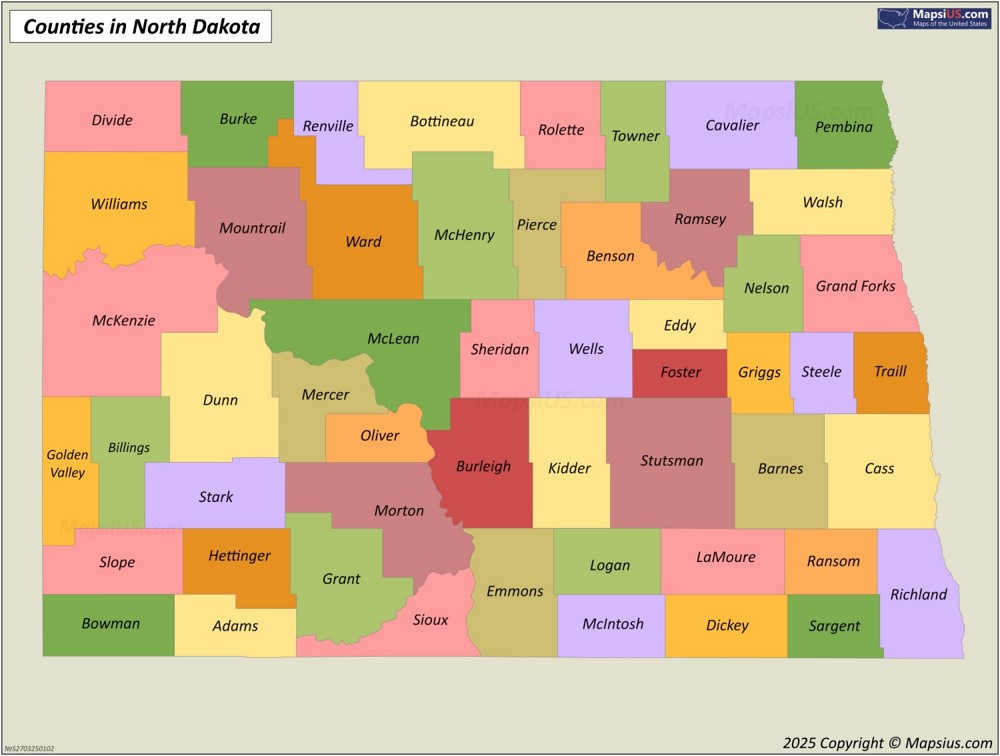
This North Dakota County Map shows the state border, county borders, and county names.
Attribution is required! You may download, print or use the above map for educational, personal and non-commercial purposes. You must place a hyperlink (to this page) with attribution next to the image you use.
Map of Counties and County Seats in North Dakota

About the map:
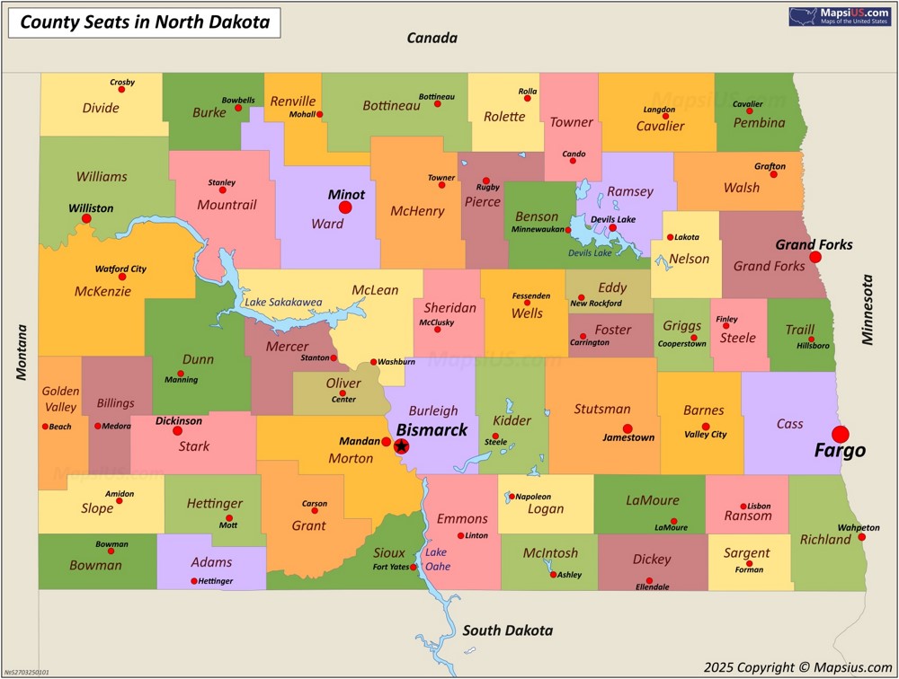
This Map of Counties and County Seats in North Dakota shows Canada–United States border, lakes, state borders, state names, state capital city, county borders, county names and county seats.
County seats are indicated by a red circle, the state capital city is indicated by a star in the red circle. The larger the city in terms of population, the larger the circle on the map and the larger the font of the city name.
Attribution is required! You may download, print or use the above map for educational, personal and non-commercial purposes. You must place a hyperlink (to this page) with attribution next to the image you use.
List of counties in North Dakota
North Dakota consists of 53 counties, each of which is an administrative region of the state. McKenzie County, the largest in area, covers approximately 2,860 square miles (7,409 km2). Cass County, the most populous, is home to more than 200,945 people.
| County | County Seat | Area | Population (2024)[1] | FIPS Code |
|---|---|---|---|---|
| Adams County | Hettinger | 988 sq mi (2,559 km2) | 2,141 | 001 |
| Barnes County | Valley City | 1,492 sq mi (3,864 km2) | 10,798 | 003 |
| Benson County | Minnewaukan | 1,389 sq mi (3,597 km2) | 5,756 | 005 |
| Billings County | Medora | 1,152 sq mi (2,984 km2) | 1,063 | 007 |
| Bottineau County | Bottineau | 1,669 sq mi (4,323 km2) | 6,391 | 009 |
| Bowman County | Bowman | 1,162 sq mi (3,010 km2) | 2,886 | 011 |
| Burke County | Bowbells | 1,104 sq mi (2,859 km2) | 2,154 | 013 |
| Burleigh County | Bismarck | 1,633 sq mi (4,229 km2) | 103,107 | 015 |
| Cass County | Fargo | 1,766 sq mi (4,574 km2) | 200,945 | 017 |
| Cavalier County | Langdon | 1,489 sq mi (3,856 km2) | 3,567 | 019 |
| Dickey County | Ellendale | 1,131 sq mi (2,929 km2) | 4,930 | 021 |
| Divide County | Crosby | 1,259 sq mi (3,261 km2) | 2,124 | 023 |
| Dunn County | Manning | 2,010 sq mi (5,206 km2) | 4,031 | 025 |
| Eddy County | New Rockford | 632 sq mi (1,637 km2) | 2,309 | 027 |
| Emmons County | Linton | 1,510 sq mi (3,911 km2) | 3,209 | 029 |
| Foster County | Carrington | 635 sq mi (1,645 km2) | 3,323 | 031 |
| Golden Valley County | Beach | 1,002 sq mi (2,595 km2) | 1,795 | 033 |
| Grand Forks County | Grand Forks | 1,438 sq mi (3,724 km2) | 73,771 | 035 |
| Grant County | Carson | 1,660 sq mi (4,299 km2) | 2,247 | 037 |
| Griggs County | Cooperstown | 708 sq mi (1,834 km2) | 2,227 | 039 |
| Hettinger County | Mott | 1,132 sq mi (2,932 km2) | 2,419 | 041 |
| Kidder County | Steele | 1,352 sq mi (3,502 km2) | 2,371 | 043 |
| LaMoure County | LaMoure | 1,147 sq mi (2,971 km2) | 4,051 | 045 |
| Logan County | Napoleon | 993 sq mi (2,572 km2) | 1,880 | 047 |
| McHenry County | Towner | 1,874 sq mi (4,854 km2) | 5,135 | 049 |
| McIntosh County | Ashley | 975 sq mi (2,525 km2) | 2,461 | 051 |
| McKenzie County | Watford City | 2,742 sq mi (7,102 km2) | 14,782 | 053 |
| McLean County | Washburn | 2,110 sq mi (5,465 km2) | 9,845 | 055 |
| Mercer County | Stanton | 1,045 sq mi (2,707 km2) | 8,348 | 057 |
| Morton County | Mandan | 1,926 sq mi (4,988 km2) | 34,194 | 059 |
| Mountrail County | Stanley | 1,824 sq mi (4,724 km2) | 9,474 | 061 |
| Nelson County | Lakota | 982 sq mi (2,543 km2) | 3,007 | 063 |
| Oliver County | Center | 724 sq mi (1,875 km2) | 1,882 | 065 |
| Pembina County | Cavalier | 1,119 sq mi (2,898 km2) | 6,588 | 067 |
| Pierce County | Rugby | 1,018 sq mi (2,637 km2) | 3,853 | 069 |
| Ramsey County | Devils Lake | 1,186 sq mi (3,072 km2) | 11,510 | 071 |
| Ransom County | Lisbon | 863 sq mi (2,235 km2) | 5,590 | 073 |
| Renville County | Mohall | 875 sq mi (2,266 km2) | 2,376 | 075 |
| Richland County | Wahpeton | 1,437 sq mi (3,722 km2) | 16,658 | 077 |
| Rolette County | Rolla | 902 sq mi (2,336 km2) | 11,692 | 079 |
| Sargent County | Forman | 859 sq mi (2,225 km2) | 3,710 | 081 |
| Sheridan County | McClusky | 972 sq mi (2,517 km2) | 1,268 | 083 |
| Sioux County | Fort Yates | 1,094 sq mi (2,833 km2) | 3,713 | 085 |
| Slope County | Amidon | 1,218 sq mi (3,155 km2) | 660 | 087 |
| Stark County | Dickinson | 1,338 sq mi (3,465 km2) | 33,767 | 089 |
| Steele County | Finley | 712 sq mi (1,844 km2) | 1,767 | 091 |
| Stutsman County | Jamestown | 2,222 sq mi (5,755 km2) | 21,546 | 093 |
| Towner County | Cando | 1,025 sq mi (2,655 km2) | 2,051 | 095 |
| Traill County | Hillsboro | 862 sq mi (2,233 km2) | 7,989 | 097 |
| Walsh County | Grafton | 1,282 sq mi (3,320 km2) | 10,214 | 099 |
| Ward County | Minot | 2,013 sq mi (5,214 km2) | 68,427 | 101 |
| Wells County | Fessenden | 1,271 sq mi (3,292 km2) | 3,803 | 103 |
| Williams County | Williston | 2,071 sq mi (5,364 km2) | 40,763 | 105 |
