New York State County Map
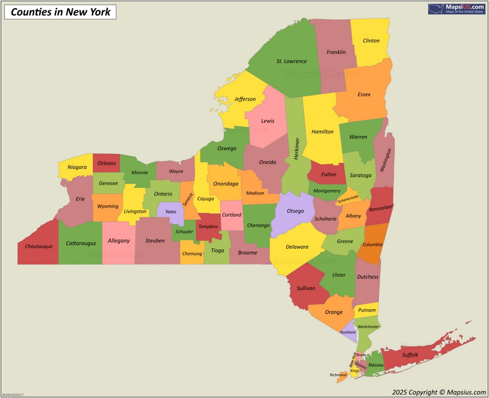
New York State consists of 62 counties, each of which functions as a local government unit.

About the map:
This New York State County Map shows the state border, county borders, and county names.
Attribution is required! You may download, print or use the above map for educational, personal and non-commercial purposes. You must place a hyperlink (to this page) with attribution next to the image you use.
Map of Counties and County Seats in New York State

About the map:
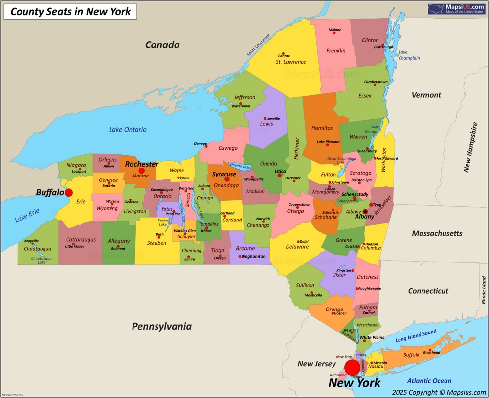
This Map of Counties and County Seats in New York State shows state borders, state names, state capital city, lakes, county borders, county names and county seats.
County seats are indicated by a red circle, the state capital city is indicated by a star in the red circle. The larger the city in terms of population, the larger the circle on the map and the larger the font of the city name.
Attribution is required! You may download, print or use the above map for educational, personal and non-commercial purposes. You must place a hyperlink (to this page) with attribution next to the image you use.
List of counties in New York State
New York State consists of 62 counties, each of which is an administrative region of the state. St. Lawrence County, the largest in area, covers approximately 2,821 square miles (7,306 km2). Kings County, the most populous, is home to more than 2,617,631 people.
| County | County Seat | Area | Population (2024)[1] | FIPS Code |
|---|---|---|---|---|
| Albany County | Albany | 533 sq mi (1,380 km2) | 319,964 | 001 |
| Allegany County | Belmont | 1,034 sq mi (2,678 km2) | 47,299 | 003 |
| Bronx County | none (sui generis) | 57.43 sq mi (149 km2) | 1,384,724 | 005 |
| Broome County | Binghamton | 715 sq mi (1,852 km2) | 196,397 | 007 |
| Cattaraugus County | Little Valley | 1,310 sq mi (3,393 km2) | 75,475 | 009 |
| Cayuga County | Auburn | 864 sq mi (2,238 km2) | 74,567 | 011 |
| Chautauqua County | Mayville | 1,500 sq mi (3,885 km2) | 124,105 | 013 |
| Chemung County | Elmira | 410.81 sq mi (1,064 km2) | 81,115 | 015 |
| Chenango County | Norwich | 898.85 sq mi (2,328 km2) | 45,776 | 017 |
| Clinton County | Plattsburgh | 1,118 sq mi (2,896 km2) | 77,871 | 019 |
| Columbia County | Hudson | 648 sq mi (1,678 km2) | 60,299 | 021 |
| Cortland County | Cortland | 502 sq mi (1,300 km2) | 45,945 | 023 |
| Delaware County | Delhi | 1,468 sq mi (3,802 km2) | 44,191 | 025 |
| Dutchess County | Poughkeepsie | 825 sq mi (2,137 km2) | 299,963 | 027 |
| Erie County | Buffalo | 1,227 sq mi (3,178 km2) | 950,602 | 029 |
| Essex County | Elizabethtown | 1,916 sq mi (4,962 km2) | 36,744 | 031 |
| Franklin County | Malone | 1,697 sq mi (4,395 km2) | 47,086 | 033 |
| Fulton County | Johnstown | 533 sq mi (1,380 km2) | 52,073 | 035 |
| Genesee County | Batavia | 495 sq mi (1,282 km2) | 57,604 | 037 |
| Greene County | Catskill | 658 sq mi (1,704 km2) | 46,903 | 039 |
| Hamilton County | Lake Pleasant | 1,808 sq mi (4,683 km2) | 5,082 | 041 |
| Herkimer County | Herkimer | 1,458 sq mi (3,776 km2) | 59,585 | 043 |
| Jefferson County | Watertown | 1,857 sq mi (4,810 km2) | 113,140 | 045 |
| Kings County | none (sui generis) | 96.9 sq mi (251 km2) | 2,617,631 | 047 |
| Lewis County | Lowville | 1,290 sq mi (3,341 km2) | 26,570 | 049 |
| Livingston County | Geneseo | 640 sq mi (1,658 km2) | 61,561 | 051 |
| Madison County | Wampsville | 662 sq mi (1,715 km2) | 67,072 | 053 |
| Monroe County | Rochester | 1,366 sq mi (3,538 km2) | 752,202 | 055 |
| Montgomery County | Fonda | 410 sq mi (1,062 km2) | 49,648 | 057 |
| Nassau County | Mineola | 453 sq mi (1,173 km2) | 1,392,438 | 059 |
| New York County | none (sui generis) | 33.77 sq mi (87 km2) | 1,660,664 | 061 |
| Niagara County | Lockport | 1,140 sq mi (2,953 km2) | 209,570 | 063 |
| Oneida County | Utica | 1,213 sq mi (3,142 km2) | 228,347 | 065 |
| Onondaga County | Syracuse | 806 sq mi (2,088 km2) | 469,812 | 067 |
| Ontario County | Canandaigua | 662 sq mi (1,715 km2) | 113,012 | 069 |
| Orange County | Goshen | 839 sq mi (2,173 km2) | 411,767 | 071 |
| Orleans County | Albion | 817 sq mi (2,116 km2) | 39,686 | 073 |
| Oswego County | Oswego | 1,312 sq mi (3,398 km2) | 118,305 | 075 |
| Otsego County | Cooperstown | 1,003 sq mi (2,598 km2) | 60,524 | 077 |
| Putnam County | Carmel Hamlet | 246 sq mi (637 km2) | 98,409 | 079 |
| Queens County | none (sui generis) | 178.28 sq mi (462 km2) | 2,316,841 | 081 |
| Rensselaer County | Troy | 665 sq mi (1,722 km2) | 160,749 | 083 |
| Richmond County | none (sui generis) | 102.5 sq mi (265 km2) | 498,212 | 085 |
| Rockland County | New City | 199 sq mi (515 km2) | 348,144 | 087 |
| Saratoga County | Ballston Spa | 844 sq mi (2,186 km2) | 240,360 | 091 |
| Schenectady County | Schenectady | 210 sq mi (544 km2) | 162,261 | 093 |
| Schoharie County | Schoharie | 626 sq mi (1,621 km2) | 30,151 | 095 |
| Schuyler County | Watkins Glen | 342 sq mi (886 km2) | 17,121 | 097 |
| Seneca County | Waterloo | 325 sq mi (842 km2) | 32,650 | 099 |
| St. Lawrence County | Canton | 2,821 sq mi (7,306 km2) | 106,198 | 089 |
| Steuben County | Bath | 1,404 sq mi (3,636 km2) | 92,015 | 101 |
| Suffolk County | Riverhead | 2,373 sq mi (6,146 km2) | 1,535,909 | 103 |
| Sullivan County | Monticello | 997 sq mi (2,582 km2) | 80,450 | 105 |
| Tioga County | Owego | 523 sq mi (1,355 km2) | 47,574 | 107 |
| Tompkins County | Ithaca | 476 sq mi (1,233 km2) | 105,602 | 109 |
| Ulster County | Kingston | 1,161 sq mi (3,007 km2) | 182,977 | 111 |
| Warren County | Queensbury | 870 sq mi (2,253 km2) | 65,288 | 113 |
| Washington County | Fort Edward | 846 sq mi (2,191 km2) | 59,839 | 115 |
| Wayne County | Lyons | 1,384 sq mi (3,585 km2) | 90,757 | 117 |
| Westchester County | White Plains | 500 sq mi (1,295 km2) | 1,006,447 | 119 |
| Wyoming County | Warsaw | 596 sq mi (1,544 km2) | 39,588 | 121 |
| Yates County | Penn Yan | 376 sq mi (974 km2) | 24,387 | 123 |
